MAP News #571 – May 6, 2023
The MAP News | |
Sea Grant Blue Carbon Law Symposium May 17-18, 2023 in Athens, GAFEATURED STORYDecades of Mangrove Forest Change: What does it mean for nature, people and the climate?  GLOBAL – Decades of Mangrove Forest Change: What does it mean for nature, people and the climate? reviews the extent of mangrove forest cover and considers the potential consequences of changes in mangrove extent for more than 1,000 mangrove associated species including birds, fish, plants, mammals, reptiles and amphibians. Further, the report analyses the potential consequences of changes in mangrove extent on carbon storage and for small scale fishers, demonstrating that restoration is clearly needed but showcases encouraging examples of mangrove recovery. The report highlights the need to improve our knowledge of what species use and depend upon mangroves in order to better understand the consequences of changes in mangroves on people and our natural world. It also emphasises the need for integrated thinking, by conserving, restoring and sustainably managing mangrove ecosystems in a coherent and inclusive way, and coordinating management and governance actions across local, national, regional and international scales. We urgently need to transform our relationship with nature and transition to a more equitable and sustainable future in which activities that result in ecosystem loss and degradation are a thing of the past. GLOBAL – Decades of Mangrove Forest Change: What does it mean for nature, people and the climate? reviews the extent of mangrove forest cover and considers the potential consequences of changes in mangrove extent for more than 1,000 mangrove associated species including birds, fish, plants, mammals, reptiles and amphibians. Further, the report analyses the potential consequences of changes in mangrove extent on carbon storage and for small scale fishers, demonstrating that restoration is clearly needed but showcases encouraging examples of mangrove recovery. The report highlights the need to improve our knowledge of what species use and depend upon mangroves in order to better understand the consequences of changes in mangroves on people and our natural world. It also emphasises the need for integrated thinking, by conserving, restoring and sustainably managing mangrove ecosystems in a coherent and inclusive way, and coordinating management and governance actions across local, national, regional and international scales. We urgently need to transform our relationship with nature and transition to a more equitable and sustainable future in which activities that result in ecosystem loss and degradation are a thing of the past.GLOBAL Machine learning could help save mangrove forests AFRICA Longstanding behavioural stability in West Africa extends to the Middle Pleistocene at Bargny, coastal Senegal
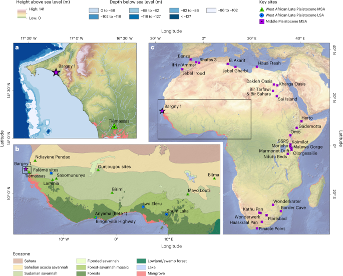 AFRICAN CONTINENT – Middle Stone Age (MSA) technologies first appear in the archaeological records of northern, eastern and southern Africa during the Middle Pleistocene epoch. The absence of MSA sites from West Africa limits evaluation of shared behaviours across the continent during the late Middle Pleistocene and the diversity of subsequent regionalized trajectories. Here we present evidence for the late Middle Pleistocene MSA occupation of the West African littoral at Bargny, Senegal, dating to 150 thousand years ago. Palaeoecological evidence suggests that Bargny was a hydrological refugium during the MSA occupation, supporting estuarine conditions during Middle Pleistocene arid phases. The stone tool technology at Bargny presents characteristics widely shared across Africa in the late Middle Pleistocene but which remain uniquely stable in West Africa to the onset of the Holocene. We explore how the persistent habitability of West African environments, including mangroves, contributes to distinctly West African trajectories of behavioural stability. Mangroves have high habitat heterogeneity and accessible subsistence resources, making them potential hotspots for Pleistocene forager populations. Adaptation to exploit these resources has the potential to open new axes for population expansions in West Africa. AFRICAN CONTINENT – Middle Stone Age (MSA) technologies first appear in the archaeological records of northern, eastern and southern Africa during the Middle Pleistocene epoch. The absence of MSA sites from West Africa limits evaluation of shared behaviours across the continent during the late Middle Pleistocene and the diversity of subsequent regionalized trajectories. Here we present evidence for the late Middle Pleistocene MSA occupation of the West African littoral at Bargny, Senegal, dating to 150 thousand years ago. Palaeoecological evidence suggests that Bargny was a hydrological refugium during the MSA occupation, supporting estuarine conditions during Middle Pleistocene arid phases. The stone tool technology at Bargny presents characteristics widely shared across Africa in the late Middle Pleistocene but which remain uniquely stable in West Africa to the onset of the Holocene. We explore how the persistent habitability of West African environments, including mangroves, contributes to distinctly West African trajectories of behavioural stability. Mangroves have high habitat heterogeneity and accessible subsistence resources, making them potential hotspots for Pleistocene forager populations. Adaptation to exploit these resources has the potential to open new axes for population expansions in West Africa.AMERICASChanges in mangrove coverage classification criteria could impact the conservation of mangroves in Mexico Save Endangered Species From SpaceX Urge SpaceX and the Federal Aviation Administration to do more to protect Boca Chica and its wildlife. SIGN THE PETITION Elon Musk’s SpaceX launch site threatens wildlife 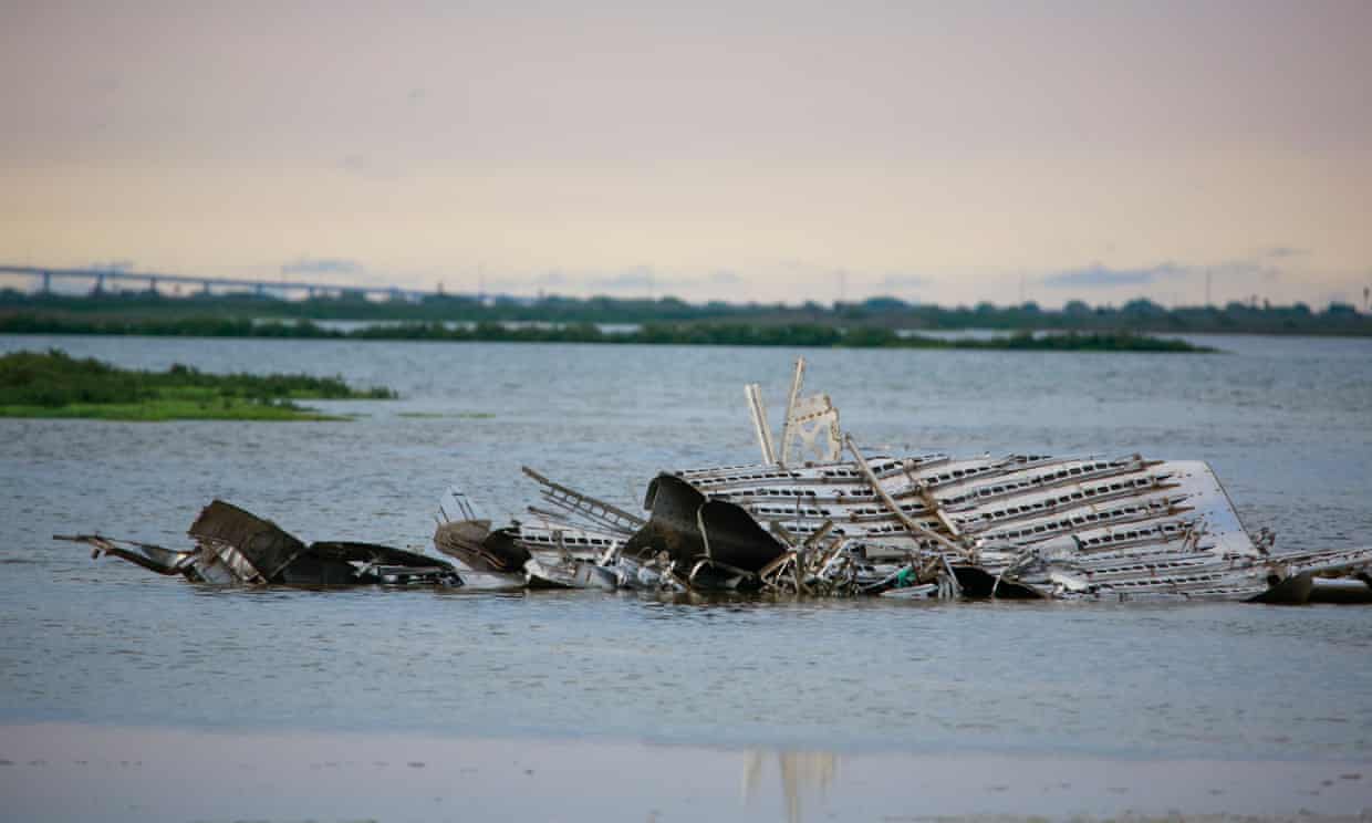 The site in Boca Chica, south Texas is surrounded by protected lands that host a huge range of local wildlife including turtles and hundreds of bird species. David Newstead, director of the nonprofit Coastal Bend Bays and Estuaries, felt sick as he saw the fireball explode on the launchpad. SpaceX’s site is surrounded by state and federally protected lands. The explosion littered parts of the delicate ecosystem of the Boca Chica tract of the Lower Rio Grande Valley national wildlife refuge – comprising tidal flats, beaches, grasslands and coastal dunes that host a huge range of wildlife – with rocket debris “I knew from the other explosions that the rocket would be scattered all over the refuge,” Newstead said. Cleanup took three months, he added The private space race is already causing concern about the potential climate impacts of the fuel needed to propel the rockets. But environmentalists on the ground in south Texas say SpaceX’s testing site is having more immediate impacts. The refuge is made up of parcels the US Fish and Wildlife Service has been buying or leasing since 1979 when the federal agency came up with its plan to preserve as much of the land tucked against the Gulf Coast and the mouth of the Rio Grande River as possible, creating a patchwork of federally managed refuge land. The site in Boca Chica, south Texas is surrounded by protected lands that host a huge range of local wildlife including turtles and hundreds of bird species. David Newstead, director of the nonprofit Coastal Bend Bays and Estuaries, felt sick as he saw the fireball explode on the launchpad. SpaceX’s site is surrounded by state and federally protected lands. The explosion littered parts of the delicate ecosystem of the Boca Chica tract of the Lower Rio Grande Valley national wildlife refuge – comprising tidal flats, beaches, grasslands and coastal dunes that host a huge range of wildlife – with rocket debris “I knew from the other explosions that the rocket would be scattered all over the refuge,” Newstead said. Cleanup took three months, he added The private space race is already causing concern about the potential climate impacts of the fuel needed to propel the rockets. But environmentalists on the ground in south Texas say SpaceX’s testing site is having more immediate impacts. The refuge is made up of parcels the US Fish and Wildlife Service has been buying or leasing since 1979 when the federal agency came up with its plan to preserve as much of the land tucked against the Gulf Coast and the mouth of the Rio Grande River as possible, creating a patchwork of federally managed refuge land.
Kennedy Space Center ‘Rescues’ Mangroves During Shoreline Restoration ASIA A Philippine town and its leaders show how mangrove restoration can succeed 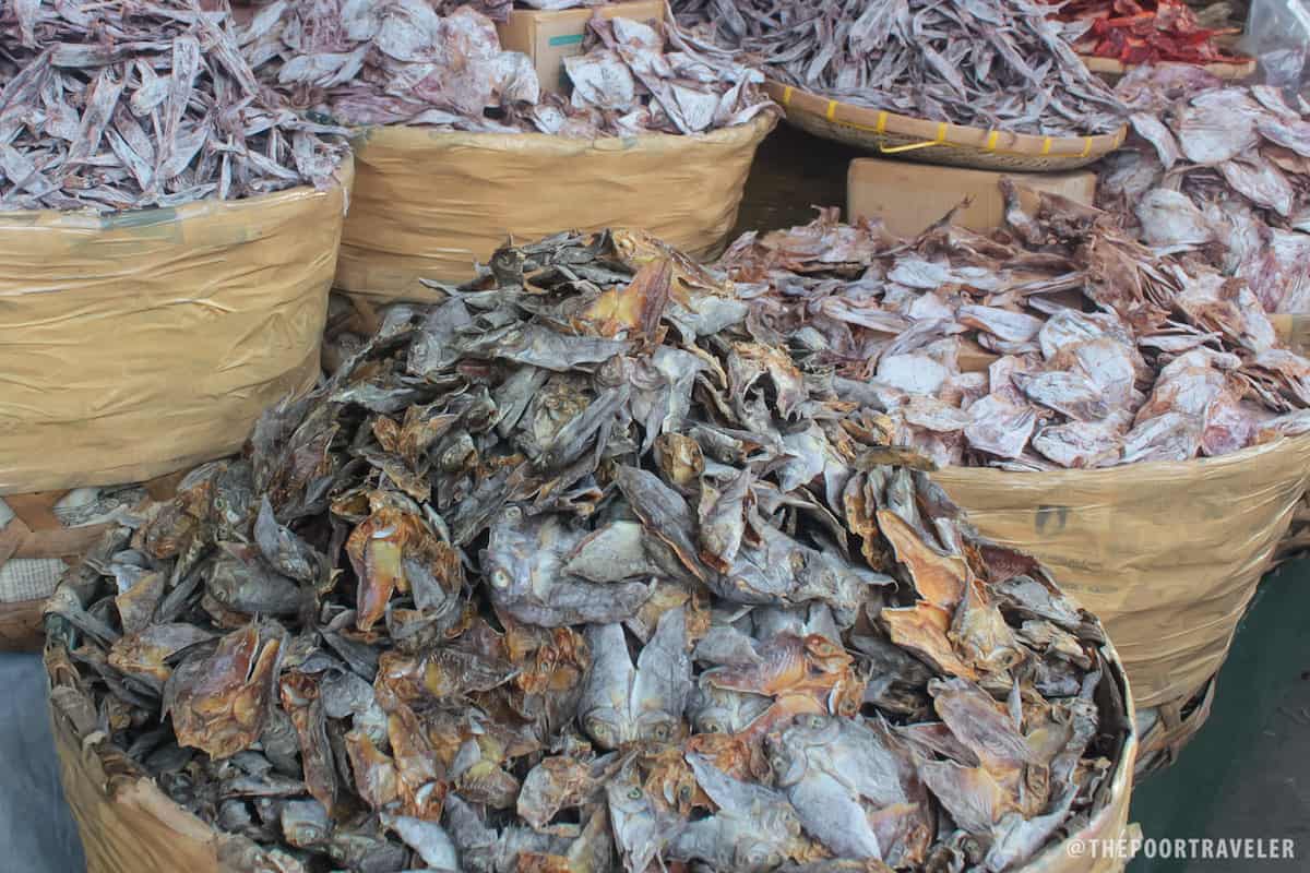 PHILIPPINES – Working quietly before a bucket of rabbitfish, known locally as danggit, two women precisely cut open each fish with square knives, gutting and deboning before repeating the process. A third woman scrubs each mirror-image fish fillet, about the size of a cigarette pack. “Today is a slow work day, but during peak seasons, such as November and December, we have a long table of 30 workers here for a ton of danggit catch,” Racquel Diño told Mongabay during a visit in mid-February. Processing danggit into dried, salted fish has become her main source of income, as it has for the two other women working today. Danggit graze on seagrass that cover 800 hectares (nearly 2,000 acres) of the seabed off the town of Prieto Diaz in Sorsogon province, 360 miles (580 kilometers) south of Manila. Prieto Diaz’s integrated marine ecosystems of seagrass meadows, coral reefs and mangrove forests are thriving, thanks to more than three decades of community-led coastal reforestation and protection efforts. With a stable population of diverse trees, its 1,034-hectare (2,555-acre) mangrove ecosystem has grown to be the largest in the Bicol region, the southeastern-most peninsula of the main island of Luzon. PHILIPPINES – Working quietly before a bucket of rabbitfish, known locally as danggit, two women precisely cut open each fish with square knives, gutting and deboning before repeating the process. A third woman scrubs each mirror-image fish fillet, about the size of a cigarette pack. “Today is a slow work day, but during peak seasons, such as November and December, we have a long table of 30 workers here for a ton of danggit catch,” Racquel Diño told Mongabay during a visit in mid-February. Processing danggit into dried, salted fish has become her main source of income, as it has for the two other women working today. Danggit graze on seagrass that cover 800 hectares (nearly 2,000 acres) of the seabed off the town of Prieto Diaz in Sorsogon province, 360 miles (580 kilometers) south of Manila. Prieto Diaz’s integrated marine ecosystems of seagrass meadows, coral reefs and mangrove forests are thriving, thanks to more than three decades of community-led coastal reforestation and protection efforts. With a stable population of diverse trees, its 1,034-hectare (2,555-acre) mangrove ecosystem has grown to be the largest in the Bicol region, the southeastern-most peninsula of the main island of Luzon. The world’s best rainforest guardians already live ther  INDONESIA – By midmorning, beams of tropical sun cut through the rainforest canopy, illuminating a bamboo hut in a rare clearing of trees. Inside, a wrinkled old man, sitting cross-legged with his eyes shut, whispers blessings to the Earth. After the spiritual leader, the Ammatoa, goes silent, groups of men wearing dark indigo sarongs jump to their feet and head into the forest carrying an offering of rattan baskets full of rice, bananas and lighted candles. “The Earth is angry with us,” said Budi, a barefoot boy crouching on the hut’s edge. “That is why the weather is getting worse. There are more rains and floods. It is getting hotter. It is because we have sinned.” This ritual is known as the Andingingi, held once a year by the Kajang, a tribe from the Indonesian island of Sulawesi. Like many parts of the world, their land has been hit by more extreme weather because of climate change. But as satellite imagery shows, the Kajang’s dense primary forest is free from roads and development, soaking up violent rains that devastate other parts of the island. As global deforestation continues at alarming rates, the empowerment of Indigenous peoples such as the Kajang is emerging as a key way to protect the world’s rainforests. A spate of recent research suggests that when armed with land rights, these communities, whose members manage half the world’s land and 80 percent of its biodiversity, are remarkably effective custodians. INDONESIA – By midmorning, beams of tropical sun cut through the rainforest canopy, illuminating a bamboo hut in a rare clearing of trees. Inside, a wrinkled old man, sitting cross-legged with his eyes shut, whispers blessings to the Earth. After the spiritual leader, the Ammatoa, goes silent, groups of men wearing dark indigo sarongs jump to their feet and head into the forest carrying an offering of rattan baskets full of rice, bananas and lighted candles. “The Earth is angry with us,” said Budi, a barefoot boy crouching on the hut’s edge. “That is why the weather is getting worse. There are more rains and floods. It is getting hotter. It is because we have sinned.” This ritual is known as the Andingingi, held once a year by the Kajang, a tribe from the Indonesian island of Sulawesi. Like many parts of the world, their land has been hit by more extreme weather because of climate change. But as satellite imagery shows, the Kajang’s dense primary forest is free from roads and development, soaking up violent rains that devastate other parts of the island. As global deforestation continues at alarming rates, the empowerment of Indigenous peoples such as the Kajang is emerging as a key way to protect the world’s rainforests. A spate of recent research suggests that when armed with land rights, these communities, whose members manage half the world’s land and 80 percent of its biodiversity, are remarkably effective custodians.
OCEANA Mangroves on Eighty Mile Beach 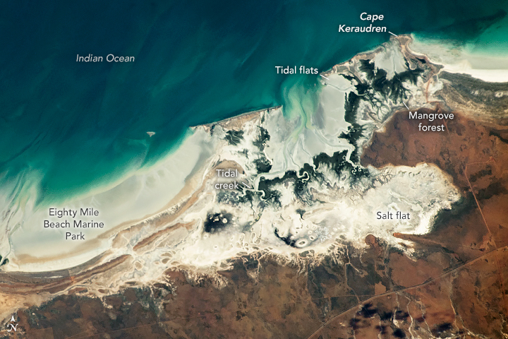 AUSTRALIA – An astronaut aboard the International Space Station photographed the western coast of Australia where mangrove forests thrive along Eighty Mile Beach. These mangrove forests are located within the Eighty Mile Beach Marine Park, a 220-kilometer (140-mile) stretch of protected beach and coastal waters in western Australia. The marine park includes the rocky shores of Cape Keraudren, where a coastal nature reserve provides access to mangrove forests and seagrass meadows. The area shown in this photograph is an example of an intertidal zone ecosystem—where the coastline is above seawater at low tide and submerged in seawater at high tide. As low tide approaches, the ebb current takes seawater toward the Indian Ocean and exposes salt flats, intertidal flats, and mangrove forests. As high tide approaches, the flood current takes seawater inland and floods the coastline. During both incoming and outgoing tides, seawater flows through coastal waterways called tidal creeks. Mangrove trees withstand the fluctuation between high and low tide by means of an elongated root system that is exposed at low tide. Local fauna, such as the north-western mangrove seasnake, can be found living in this root system. Other species, like the mangrove golden whistler, are found in the tree canopy. AUSTRALIA – An astronaut aboard the International Space Station photographed the western coast of Australia where mangrove forests thrive along Eighty Mile Beach. These mangrove forests are located within the Eighty Mile Beach Marine Park, a 220-kilometer (140-mile) stretch of protected beach and coastal waters in western Australia. The marine park includes the rocky shores of Cape Keraudren, where a coastal nature reserve provides access to mangrove forests and seagrass meadows. The area shown in this photograph is an example of an intertidal zone ecosystem—where the coastline is above seawater at low tide and submerged in seawater at high tide. As low tide approaches, the ebb current takes seawater toward the Indian Ocean and exposes salt flats, intertidal flats, and mangrove forests. As high tide approaches, the flood current takes seawater inland and floods the coastline. During both incoming and outgoing tides, seawater flows through coastal waterways called tidal creeks. Mangrove trees withstand the fluctuation between high and low tide by means of an elongated root system that is exposed at low tide. Local fauna, such as the north-western mangrove seasnake, can be found living in this root system. Other species, like the mangrove golden whistler, are found in the tree canopy. Pease consider donating to MAP to keep it going. *Articles in this newsletter may mention practices being used and/or show exagerated results being claimed without proof. Stories are presented here in effort to show mangrove related activity around the world and do not necessarily reflect Mangrove Action Project’s views or mangrove restoration best-practices. NOTICE
ACTION ALERTS | |
Mangrove Action Project Click here to view past newsletters
| |


 MEXICO – Accurate estimates of habitat extent and rates of change are cruc


